Indicators of coastline dynamics

Information for proper data use

Waterline position monitoring

Definition

Evolution

Limit between the marine and terrestrial parts of the coastal system.

Regularly spaced transects highlighting hotspots of shoreline erosion. Surface area comparison between 2 dates

Suitable for comparison of shoreline condition before/after storm.

Microtidal areas during low wave agitation conditions.

Not suitable to survey the shoreline representative of a season, or to quantify seasonal, annual, or longer-term changes.

For the conditions listed that are not suitable for this indicator, opt for the « High and low limit of the swash zone » indicator.

Upper and lower swash limit

Definition

Evolution

Highest & lowest position reached by the water on the beach over a selected homogeneous period.

Regularly spaced transects highlighting hotspots of shoreline erosion. Surface area comparison between 2 dates.

Suitable for locating the seasonal position of the shoreline, quantifying seasonal and annual changes.

Not suitable for pre-post storm change monitoring, or for a macro-tidal dune environment.

For the conditions listed that are not suitable for this indicator, opt for the “waterline » or the “dune foot position” indicators.

Dune foot position

Definition

Evolution

Change in slope at the base of the seaward side of the dune

Regularly spaced transects highlighting hotspots of shoreline erosion

Suitable for monitoring a coastline with a developed dune system, whose dynamics are multi-metric over the chosen monitoring frequency.

Not suitable for monitoring old, stable and/or poorly developed dune systems.

For the conditions listed that are not suitable for this indicator, opt for the “beach width” indicator.

Beach width

Definition

Evolution

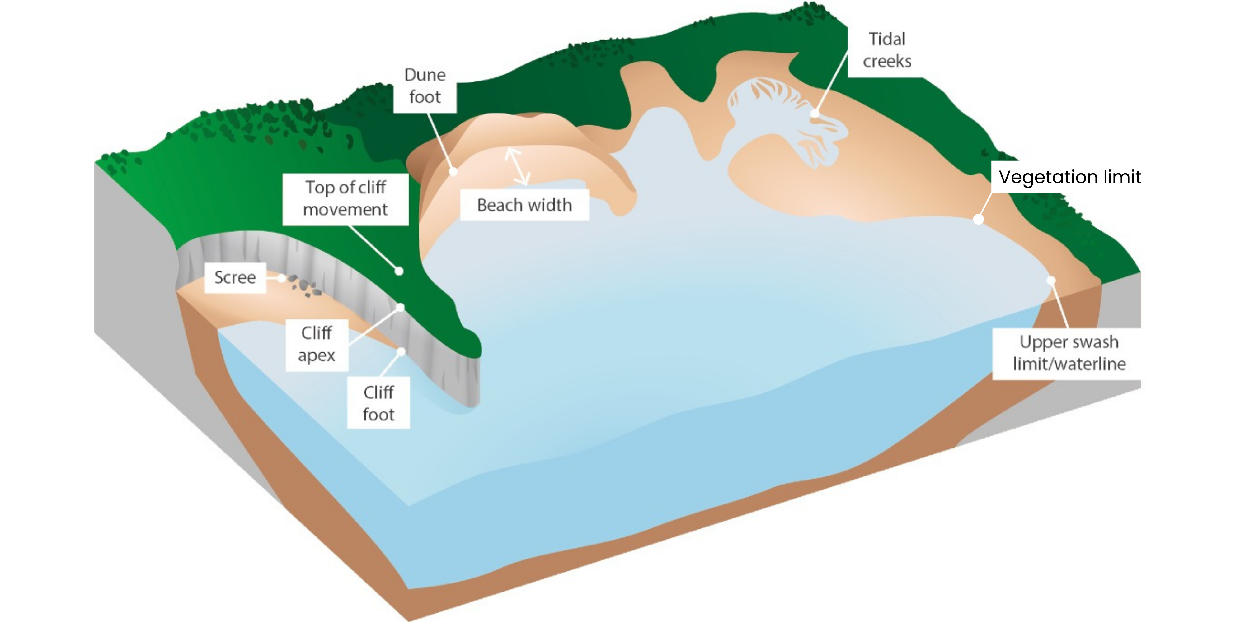
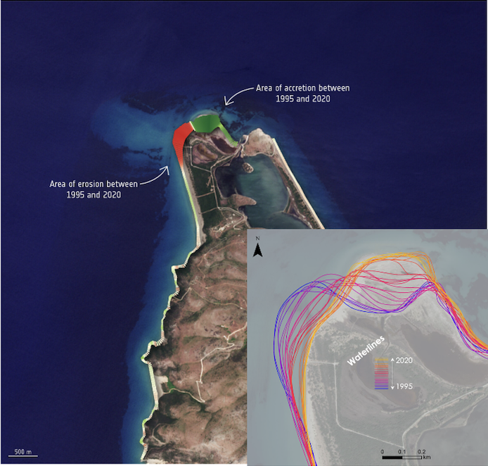
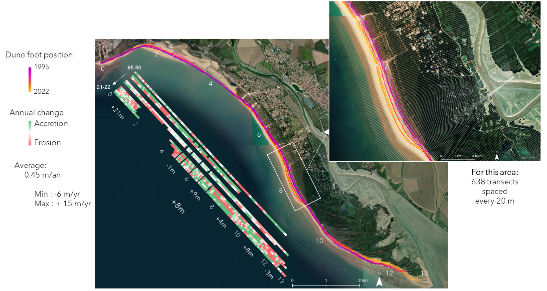
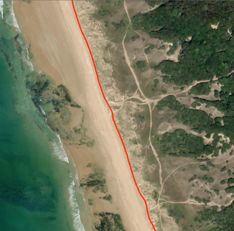
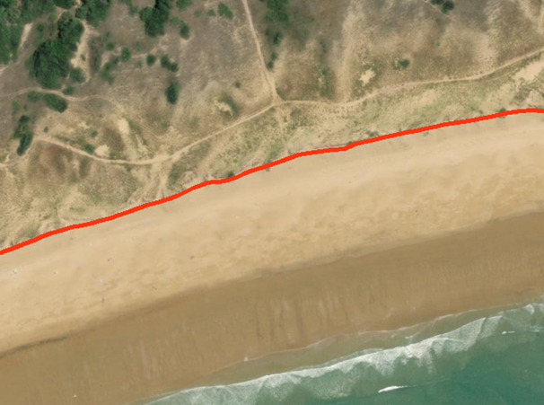
Distance between a reference line denoting the foot of either the dune, or the cliff, or a defence structure, and the waterline computed at low tide (total beach width), high tide (upper beach width) or using a time-averaged waterline (mean beach width in microtidal environment)

Regularly spaced transects highlighting hotspots of narrowing of the beach width.

Suitable for beaches several tens of metres wide, subject to dynamics at the bottom and top of the beach.

Not suitable for narrow beaches, given the resolution of the images. Adapt the selection of images according to their resolution.

For the conditions not suitable, favour a beach surface analysis. The surface area can be estimated from the beach limits used for the width calculation.

Vegetation limit

Definition

Evolution

Position of the sea-side vegetation boundary

Regularly spaced transects highlighting hotspots of vegetation squeeze.

Suitable for mature vegetation fringe, long-term trends of evolution or exceptional stormy events

Not suitable for young scattered vegetation, indirectly connected to sea, seasonal or shorter-term dynamics.

For the conditions not suitable, favour the « High and low limit of the swash zone“ or the “waterline” indicators.

Intertidal creeks and channels

Definition

Structures of differential erosion related to the influence of marine waters during tidal cycles on the sandy-muddy sedimentary material. The creek edges mark the limits of these channels

Suitable for meso- to macro-tidal sandy/muddy areas.

Not suitable for micro-tidal areas.

For the conditions not suitable, favour the « High and low limit of the swash zone“ or the “waterline” indicators.

Sea-cliffs lines

Definition

Top and bottom of cliffs to identify collapse notches.

Suitable for steep cliffs

Not suitable for stable cliffs.

For the conditions not suitable, favour the “Screes” location indicator.

Screes

Definition

Position and shape of rocky cliff collapse deposits. Combined with an analysis of the mobility of the cliff lines, the event can be dated.

Suitable for steep cliffs

Not suitable for stable cliffs.

For the conditions not suitable, favour the “gravity movements” indicator fo anticipate or observe collapse.

Gravity movements

Definition

Ground deformations are monitored to prevent or observe landslides and rocky collapses

Suitable for highly erosive subvertical sea-cliffs.

Not suitable for ancient, vegetated, and stable cliffs.

For the conditions not suitable, favour the “scree” detection to locate erosive hotspots.